The Earth Observation for Sustainable Development (EO4SD) Climate Resilience Cluster has been working with International Financial Institutes (IFIs) to develop a satellite-based integrated climate screening and risk management service to build capacity in IFI client states and help them meet long-term climate resilient development planning goals. The Cluster is supporting future environment and natural resources management (ENRM) projects in partnership with the Lake Victoria Basin Commission (LVBC) to develop an environmental management project for the Lake Victoria Basin. The LVBC coordinates the partner states of the East African Community in managing the Basin.
The Basin is Africa’s largest freshwater lake and is spread across 5 countries – Tanzania, Uganda, Kenya, Burundi and Rwanda. The ENRM projects in the Great Lakes region aim to strengthen transboundary natural resource management by improving regional information services on water quality and ecosystem health, encouraging sustainable land and water resource management (SLWM) and building climate resilience in select hotspots in the Basin. These projects will increase the LVBC’s capacity to deliver on its mandate of coordinating the management of water quality in the Basin.
The Basin currently faces multiple environmental, economic and social challenges. Different hotspots in the Basin are under pressure from a combination of factors such as high population density, land use change, and water and land pollution due to inefficient waste management and treatment. These factors are contributing to the degradation of Lake Victoria.
The Lake has turbid waters with high chlorophyll concentrations turning them green. Excessive turbidity and chlorophyll concentrations indicate high mineral density in the water and poor water quality, a problem that is being exacerbated by climate change, which will increase the rate of environmental degradation in the Lake. Rising temperatures will accelerate the growth of floating macrophytes (aquatic plants), which will reduce the oxygen content of the lake. The conditions for disease vectors such as mosquitos are also likely to become more favourable and the increasing frequency and severity of floods and droughts will further drive erosion and increase sediment in runoff.

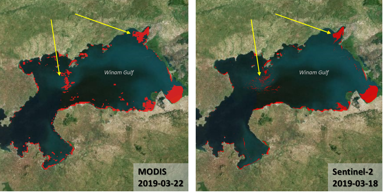
Water hyacinth in Winam Gulf (Lake Victoria). Floating water hyacinth areas are depicted in red. Obtained from satellite imagery: MODIS (250 m) on 22nd March 2019 (left) and Sentinel-2 (10 m) on 18th March 2019 (right). More explanations in this Youtube video.

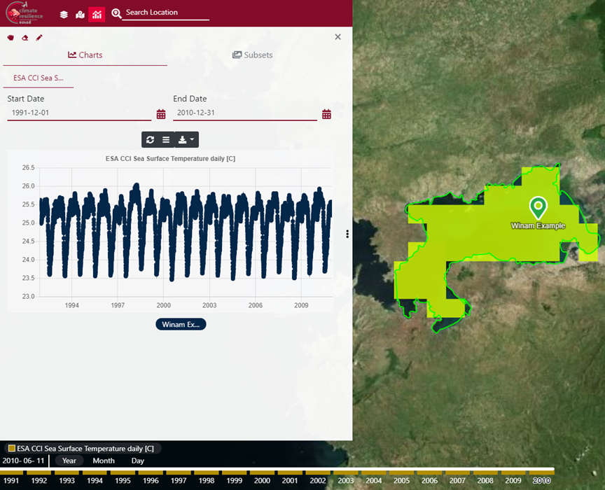
The image shows us the trend in lake surface temperature in the Basin from 1991 to 2010. Displayed in the EO4SD CR platform
Hotspots under pressure
In the Nyabugogo catchment in Rwanda, one of the Lake Victoria’s hotspots, urban settlements within the catchment are already living with the consequences of environmental degradation due to the exploitation of natural resources for agricultural and industrial activities, severe pollution and significant changes in land use. The catchment is at high risk of fluvial and pluvial flooding, with surrounding farmland and villages being frequently inundated. The economy in the Basin area is entirely dependent on water and land resources for agriculture and industry. These effects will be exacerbated by changing climate patterns and climate related events, threatening the economic stability of the region.
Following a high-level climate risk analysis of the Nyabugogo catchment, the cluster identified several adaptation options along with relevant EO data layers. One of the options identified involves synthesis of multi-parameter remote sensing data to monitor and manage catchment changes, which will help monitor catchment health and identify and remedy incipient catchment hazards. This can be enabled by building the GIS and Remote Sensing (RS) capacity of LVBC to enable them to receive, store and synthesise up-to-date and quality remotely sensed spatial data and information on the Basin. Data may cover a broad spectrum of themes, such as lake levels, lake water quality, water hyacinth, land use/land cover changes and biodiversity trends.

Shoreline changes in the mouth of the Nyando River from 1984 to 2019. Its basin is one of the most degraded of all the river basins in the Kenyan portion of the Lake Victoria Basin. False colour is chosen to emphasize changes in vegetation. Plant-covered land is red. Water bodies are dark blue, while turbid water appears in shades of cyan compared to clear water.
Products developed by the cluster include the historic evolution of hyacinth and lake surface temperature, along with the evolution of lake shoreline erosion, for the Winam Gulf part of the Basin. This information can be used, for example, to identify the location and sources of pollution hotspots in industrial and agricultural areas. Following the development of these prototypes, the climate resilience cluster plans to extend the analysis to other hot spots of the Lake Victoria as part of a regular monitoring service, such as monthly changes in water hyacinth cover or lake shoreline erosion. Access to this level of data can improve the LVBC’s capacity to manage its resources across country boundaries and improve regulations to meet the immediate and long-term needs of the Basin to maintain its ecological integrity.
The datasets used for the Lake Victoria project, land surface temperature (LST) and water hyacinth detection (currently based on vegetation indexes) are global and can be provided for other parts of the world. The products developed for Lake Victoria Basin can also be applied to other areas, improving data availability for informed decision making and for mainstreaming climate resilience in development planning.


