The European Space Agency’s (ESA) Earth Observation for Sustainable Development (EO4SD) climate resilience cluster, is working with the World Bank to provide Earth observation data in support of its Monrovia Integrated Development Project (MIDP). Although focussed on the Liberian capital, the MIDP aims to identify pragmatic, spatially integrated, and location specific interventions that contribute to service delivery, improved welfare, and the creation of jobs throughout the country. To support the World Bank and its stakeholders, The EO4SD climate cluster has provided several products including modelling sea level rise and its impacts on coastal population (coastal and inland flooding) and coastal shoreline erosion based on historical evidence. Earth observation (EO) data and climate projection derived information can be used to model the impacts of disaster and climate change on the developed land, and offer alternative scenarios of how Monrovia could develop.

A turbulent history
For the past several decades, Liberia has experienced dramatic levels of urbanisation. This trend is primarily a product of its history of instability and conflict. Years of civil war during the late 20th century killed several hundred thousand people and displaced more than a million others, half of Liberia’s population at the time. As of 2018, Liberia remained one of the poorest countries in the world, with its potential for economic growth and job creation remaining largely unexploited. Low capital investments in economic and social infrastructure have exacerbated the development challenges in the country.
With Liberia continuing to urbanise at pace, climate change is projected to aggravate existing developmental challenges, slowing down economic growth through reduced productivity from climate-sensitive sectors and damage to critical infrastructure. Climate change also poses critical threats to Liberia’s public health, the agriculture sector, and its coastal zone where much of the population and assets are concentrated.
Liberia’s capital city, Monrovia, has all the characteristics of a fragile city. A majority of the population in Greater Monrovia lives in slums, with some being subject to frequent flooding, a problem that will be exacerbated by climate change. Electricity and piped water are scarce and are typically found in houses belonging to the upper class. Additionally, Greater Monrovia’s road capacity and education systems lag far behind those of other cities.
The World Bank’s MIDP aims to identify adaptation policies that can help Monrovia be better prepared to absorb urban growth in a context of extreme poverty, fragility and increasing risks from climate change. Several adaptation solutions were offered up by the EO4SD climate cluster, but two activities were ultimately chosen to compliment the World Bank’s Great Monrovia Urban Review project.
1) Soil erosion service
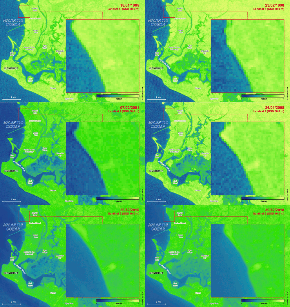
Since 2013, sea level rise and coastal erosion has displaced more than 6,500 and destroyed 800 houses in the West Point township of Monrovia. Sea level rise leads to erosion and causes the shoreline to retreat landwards, increasing the risk of displacement. Dwellings built in 2010, favoured by land gains due to the shoreline and river dynamics, are at a high risk of flooding.
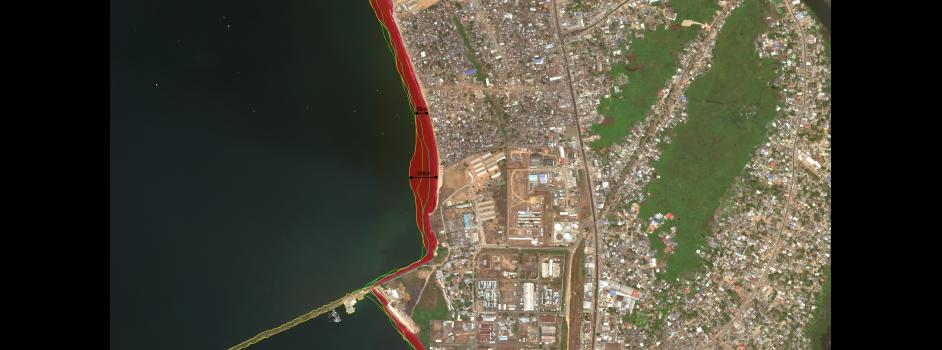
To support this issue, the cluster undertook shoreline monitoring and change detection in Greater Monrovia, evidencing 41km shoreline changes from a 34-year satellite (1984-2019) series. The service uses a thoroughly tested methodology for consistent and reliable water body detection based on High Resolution optical imagery. Optimal regular detection of surface water was obtained through appropriate spectral indices and biophysical variables derived from the EO images. The analysis estimates that the land loss area from 1984 to 2019 in the Greater Monrovia's coastline is not likely to be less than 0.8 square kilometres.
The soil erosion service based on EO data helps the World Bank determine where to best make investments and identify hotspot areas that need immediate attention.
Shoreline retreat from 1984 to 2019 in New Kru Town (Greater Monrovia)
2) Flood Risk Service
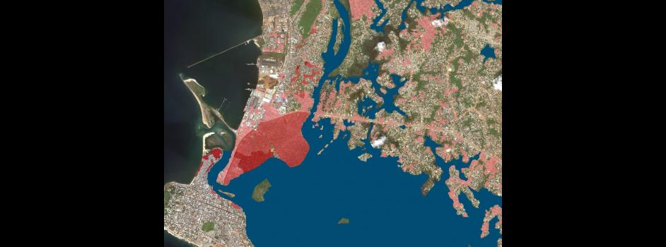
The second EO based service involves hot spot analysis of flood modelling in Monrovia, evidencing the potential coastal and inland flooding for the city in the year 2030. Using high-resolution sea-level rise data obtained from shoreline change in Monrovia’s metropolitan area from 1985 to 2019, the sea level rise estimation is used to identify coastal and inland flood risk areas. The potential of these flood events is then combined with population exposure obtained from the population density (2007 census) in Clara Town, Monrovia to estimate the flood risk to the general population.
The flood risk analysis could also be enhanced, in future, with the inclusion of critical infrastructure analyses, hydrologic information, and projections of coastal erosion and land subsidence. These flood maps can help authorities to identify the most effective actions to manage flood risk, develop adaptation plans, consider where natural flood management could be most effective, and enable better planning decisions to avoid unnecessary development in flood risk areas. This illustrates how EO can support the implementation of climate adaptation solutions for regions affected by sea level rise and flooding.
Hotspot analysis of flood risk intersected with population density for Clara Town (Greater Monrovia). Risk severity depicted by red gradient colours
Next steps and potential for additional application?
The two prototype services described above were delivered within the first phase of the EO4SD climate resilience cluster project, ending July 2019. In the second phase of the project, which runs until June 2021, further EO-based services will be provided, including integration of climate projections and socioeconomic data in the flood risk analysis, to better identify climate risks, and an estimation of projected coastal erosion up to 2030. New products and services can also be provided for different hazards or locations. With the World Bank’s MIDP project currently in its planning stages, these EO-based services help lay the groundwork for the World Bank team and city stakeholders in identifying key climate-resilient interventions for the city of Monrovia, to be implemented over the coming years.


